Clik here to view.
Stage 15 on the Ruta Maya is Epic, 2650 meters up and 2850 down over 116 km with a 30 km off road gauntlet in the middle. It’s also the last of a 4 day stretch featuring more than 9000 meters total climbing between Valle de Angeles and Copan Ruinas.
Image may be NSFW.
Clik here to view.
I chose the seemingly wise decision of starting at lunch just before the toughest dirt climbs, which I calculated would total about 1000 meters up, with the aim of arriving at our Copan rest day well exercised but not exhausted. Setting out I felt great, legs were strong, and I handled the several 18% up pitches with relative ease. After 9 km at a Y intersection the main road went left and given most of the flagging tape was affixed to a sign pointing to San Agustin, 13 km distance, that direction appeared the logical one.
Image may be NSFW.
Clik here to view.
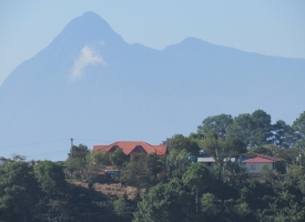
After another hour of steep ascents and descents through spectacular scenery I arrived in the plaza of this attractive small rural town confident that I only had 5 km of off-road left and would arrive at Copan by 12:30 PM …only to find … no flagging tape. I phoned Cristiano our tour leader who consulted google maps and solemnly advised I had missed a key turn and had no choice but to backtrack. There had been a tuk tuk cruising the streets but it was now nowhere to be found. No matter, I bought an “Amp” (tasty drink akin to Red Bull light), and proceeded to retrace the 13 km back over hill and dale. After 5 more km I arrived at another T intersection where the flag tape indicated “go right, oh cycling adventurer”. But unbeknownst to me … and 3 other riders as it turned out … here the local kids had decided to move the tape from one side of the road to the other… Descending the steep muddy track I then came to another remote intersection where there was, of course, no orange tape in sight. Just then a farmer was let out of a vehicle and I told him “pienso que estoy perdido, cual es la direccion hasta la Pan Americana?” (I think I’m lost, which way to the Pan American highway?) He assured me that if I turned left and went passed his house that I would reach the pavement in 5 or 6 km.
Image may be NSFW.
Clik here to view.
While I was down to 1/3 of a bottle of fluid, the adrenaline was flowing, and I set off per his recommendation on a rocky trail that went straight up, then straight down, and then straight up, all at a 25%+ gradient. Fortunately after 45 minutes or so I came to a junction and glancing right, lo and behold there it was … the elusive flagging tape! A few steep skidding descents later I finlly reached the tarmac. 3 minutes later, after I hadn’t seen anyone from our group for 7 hours, Cristiano appeared in his runabout with another lost soul, Marek, my roommate and buddy. While I had been worried, Cris was going thru a bit of hell, with 4 missing riders. He exclaimed “Brian I have never been happier to see you” and after passing each of us a cold Gatorade and a Snickers bar, Marek and I set off on the final 30 km into Copan, arriving at our hotel just before 5 PM, where we gulped down some ice cold Salva Vida cervezas.
Image may be NSFW.
Clik here to view.
All told I had climbed 1800 meters and descended 2200 over 52 kms of dirt, hardly the original plan, but still a rewarding journey that I will never forget or in hindsight, regret. In the end it had been just another extraordinary day on tour with TDA Global Cycling.
